
Near Da Lat, on Langbiang Mountain, there is a dog that walks ahead of hikers to show them the way. Known as "Vàng" (meaning yellow) for its coat color, this 3–4-year-old dog belongs to a resident living near the entrance to the tourist area. It joins groups of climbers of its own accord, stops and waits if it gets too far ahead, and leaves on its own once the route is done. Resident Nguyen Minh Phuong registered the dog on Google Maps under the location name "Cậu Vàng Langbiang." The map listing appeared but was later removed, and re-registration is currently pending. Few people would make the trip up the mountain just for the dog, but for Japanese travelers heading to Da Lat, both the practicalities of climbing this 2,167-meter mountain and the insight into what locals choose to put on the map are useful pieces of information.
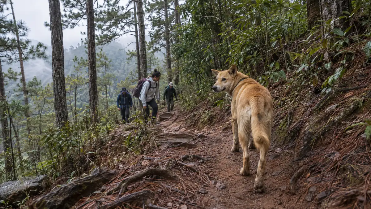
A dog that sets off walking ahead of hikers exists on Langbiang Mountain
According to VnExpress, Vàng isgentle, familiar with the mountain trails, and eager to guide hikersIt walks ahead, stops and waits for those behind when the gap grows, then sets off again. Repeating this pattern, it accompanies hikers to the summit, then leaves of its own accord once the route is finished.
How many years ago it began guiding has not been reported. The owner is a resident living right near the Langbiang tourist area and has not stopped the dog from heading up the mountain on its own. No one has come forward to explain when or how it developed the habit of leading hikers to the summit.
Langbiang Mountain has a two-layer structure: a developed tourist zone and the hiking trails that continue beyond it. The trekking course covers roughly 12 kilometers in total and includes a section that passes through pine forest before entering old-growth forest. Vàng walks on the hiking trail side — not the tourist area's walking paths, but the trail that hikers climb on foot.
Why was the Google Maps location removed?
Mr. Phuong has encountered Vàng on multiple occasions, and on one of them he recounts that "Vàng appeared and guided the whole group." He registered the dog as a location to let other hikers know of its existence. The name he registered it under was "Cậu Vàng Langbiang" — a form of address that translates roughly as "Young Vàng of Langbiang" in Vietnamese.
According to reports, the location was deleted due to a technical error in the app, and re-registration is currently pending. The very idea of registering a dog as a place is the heart of this story.
There is a literary background to the name. "Cậu Vàng" is the name of the dog in Nam Cao's short story "Lão Hạc," widely read in Vietnamese schools — a dog known for being sold away amid poverty. Because Vietnamese people have a specific image in mind when they hear "Cậu Vàng," the location name needs no explanation. Translated directly into Japanese, it becomes simply "yellow dog," and that layer of meaning is lost.
Where is Langbiang Mountain relative to Da Lat, and how far can you go by vehicle?
Langbiang Mountain is located in Lac Duong District, Lam Dong Province, about 15 kilometers from Da Lat city center. The summit area is divided into several peaks, and the height accessible to tourists differs from the height reached on foot.
| Peak | Elevation | How to get there | Estimated travel time |
|---|---|---|---|
| Radar Peak (Đỉnh Radar) | 1,929 m | Jeep transfer available from the tourist area entrance | Approx. 15 minutes one way |
| Ong Peak (Đỉnh Ông) | 2,124 m | Hike the trail on foot | Approx. 3 hours going up |
| Ba Peak (Đỉnh Bà) | 2,167 meters | Hike the trail on your own two feet — Da Lat's highest peak | Approx. 3 hours going up |
The jeep goes only as far as Radar Peak, where there is a viewing platform and a small shop. Many of the Langbiang photos that circulate online were taken from this elevation. What Van guides is the side the jeep cannot reach — a section that takes roughly three hours to climb on foot. The time varies considerably depending on fitness, and quite a few people turn back partway.
November through April is the recommended season for climbing. Rain is scarce during this period, and the chances of catching a sea of clouds in the early morning are higher. Those hoping to see the sea of clouds often plan a one-night stay on the mountain.
What do hikers and locals call this dog?
Most of the reported comments simply describe the dog's behavior as observed.
- Hiker Linh Huynh said the dog guided them "with great care," consistently waiting for the group before moving on.
- Local resident Nguyen Minh Phuong said she has encountered Van on multiple occasions, recalling one instance where "Van appeared and guided everyone."
- The owner is a local resident living right near the Langbiang tourist area and has not stopped the dog from following hikers up the mountain.
- The move to register the location on Google Maps came from Phuong — a local resident — not from the tourist site's management.
What stands out in all of this is that the tourist site's operators have said nothing. No official statement has been issued, and no notice about the dog has appeared. Information is circulating only among hikers and nearby residents, and Google Maps was chosen as the means to share it with the outside world.
Locals rewriting the map is something that happens repeatedly in Vietnam
Reading the dog's location registration as a one-off feel-good story means missing something. In Vietnam, there is a pattern of residents putting information into a shareable form before government bodies or facility operators do.Hanoi's flood map— while the city's official version disappeared after 14 days, a map residents built in 4 days continued to be used.In the former Ha Giang province's Dong Van, tourists responded to videos shot on the smartphone of the local government head.In both cases, the creators were on the ground and outpaced the official sources in speed of updates.
The Langbiang location registration follows the same pattern. Information that does not appear on the tourist site's official pages is placed on a platform by someone who is actually there. As a result, the maps of Vietnam that travelers coming from Japan see contain a considerable amount of information that was not created by any government body. This is a practical point to keep in mind when researching Vietnam in advance. Even in places where the official website is thin, reading Google Maps reviews and resident posts can get you close to the current situation. Conversely, looking only at the official site and concluding "there's nothing there" means missing things.
That said, resident posts can disappear. The location in question was also deleted due to a technical error. Van is a living creature of around 3 to 4 years old, so the period during which this location name holds meaning is also limited. When relying on resident posts, it is best to check the posting date, and to treat prices and operating hours as something to verify on the ground.
If the dog becomes a reason to visit, what happens on Langbiang's side?
The concern is the burden on the dog. Van is a pet, so the situation differs from feeding wildlife, but if the number of hikers increases, so does the number of times Van accompanies them. There is no reported information to judge how much strain repeatedly going up and down a mountain trail at around 2,000 meters in elevation places on a 3-to-4-year-old dog. Whether to offer food is also unclear, since the owner's wishes are unknown — erring on the side of not feeding is the safer approach.
The risks for hikers are also real. When a dog walks ahead, hikers stop checking the route themselves. The Langbiang trail covers about 12 kilometers with an elevation gain of over 600 meters, and once inside the old-growth forest, there are places where the path splits. If the dog heads off in a different direction or does not show up, anyone without a map will be in trouble. It is safer to treat the guide dog as a happy coincidence if encountered, rather than factoring it into your plans.
How the tourist site's operators will handle this dog is not clear from what has been reported. No notice or introduction has been issued, and the reason cannot be confirmed. As a hiker, the only option is to treat Van as a presence that does not appear in any official guidance.
Practical information for visiting Langbiang Mountain
| Item | Details |
|---|---|
| Location | Lac Duong District, Lam Dong Province. Approximately 15 km from Da Lat city center |
| Highest point | Ba Peak, 2,167 m (Da Lat's highest point). Jeeps go as far as Radar Peak, 1,929 m |
| Admission | Many sources list 50,000 VND for adults and 25,000 VND for children (approx. 300 yen / approx. 150 yen). Some sources list 30,000 VND, so it is worth checking at the entrance |
| Jeep (round trip to Radar Peak) | 50,000–120,000 VND per person shared (approx. 300–730 yen). Prices vary by source. Departs once 5–6 people have gathered. Private hire is around 300,000 VND round trip (approx. 1,800 yen) |
| Hiking trail | Approximately 12 km from the tourist site entrance toward the summit. Passes through pine forest into old-growth forest |
| Ascent time | Around 3 hours depending on fitness. Those aiming for the sea of clouds may opt for a one-night stay on the mountain |
| Best season | November–April |
| Getting from Da Lat city center | Grab or motorbike. Approximately 30 minutes |
| Exchange-rate guide | 1 yen ≈ 165 VND (as of October 6, 2026) |
Prices are subject to change, so the figures above should be treated as a rough budget guide. The cost of getting from Da Lat city center is partly affected by fuel price movements —the switch to E10 affected rental cars and Grab differently— so even the same distance can cost more or less depending on the mode of transport.
Summary
Van, the guide dog of Langbiang Mountain, is the kind of encounter that counts as a bonus if it happens — not something to build an itinerary around. That said, the move by a local resident to register this dog on Google Maps is a good illustration of where on-the-ground information in Vietnam comes from.
If you are planning a trip to Da Lat, the first decision to make is whether to take the one-hour jeep ride up to Radar Peak or the half-day hike to Ba Peak. If you choose to walk, aim for the dry season from November to April, read Google Maps reviews with their posting dates before you set off, and download the trail junctions and estimated times to your map app for offline use. If the dog starts walking ahead of you that day, consider yourself lucky.