When the rain starts, traffic on Hanoi's arterial roads grinds to a halt within minutes. Lines of motorbikes jam the intersections, water covers the pavement in low-lying areas, and you can only decide which route is faster as you ride. Into this daily reality comes a system that projects information straight onto the road. Thirty-six variable message signs (VMS) that Hanoi installed on major routes and intersections began operating on July 15, 2026. Drivers on the move can check congestion, accidents, flooding, and detour routes on the screen right in front of them.
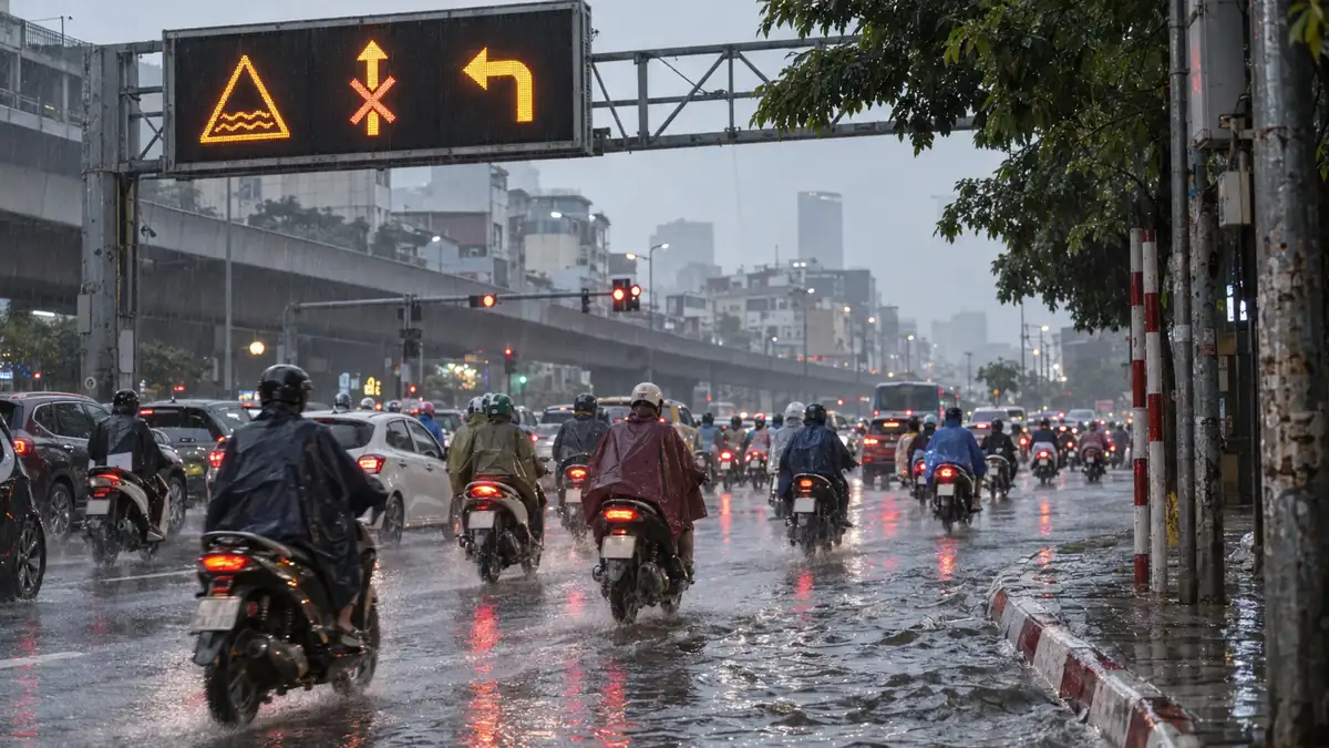
Without peering at a map app on your phone, you can read the road ahead in the few seconds of a red light. For residents who commute daily by motorbike or car, that difference is not small. Here we break down what the 36 units offer and how to actually use them.
36 Electronic Display Boards Go Live, Showing Real-Time Info on the Streets
Led by the Hanoi Public Security Department, the system installs VMS boards along the city's main routes and intersections to show congestion, accidents, flooding, detour routes, and other warnings in real time. The boards aren't standalone devices; they are the output end of a camera and signal-control network strung across the whole city. It analyzes the traffic data it gathers and turns the results into a form drivers can see, sending it back onto the road.
The project contracts were signed on March 31 and April 16, 2026, with an implementation period of about 120 days. Behind the rapid rollout is the city’s policy of shifting to traffic management built on AI and big data. The 36 message boards are the entry point to that system—not simply more signage, but part of a setup that links monitoring, analysis, and communication into one.
Congestion and flooding: the two walls Hanoi drivers have long faced
What has made getting around Hanoi difficult comes down to two things: chronic congestion and rainy-season flooding. Road expansion hasn't kept pace with the growth in population and in motorbikes and private cars, and at the morning and evening rush major intersections grind to a halt. Add the rainy season from around May to October, and low-lying areas where drainage can't keep up flood over, so a road you always use can suddenly become impassable.
Until now, residents have relied on the traffic overlays in map apps to decide on detours. But checking a phone while riding is dangerous, and especially hard on a motorbike. App traffic data also doesn't always accurately reflect road conditions like flooding. The boards installed along the streets fill this gap, letting you take in what's happening at the intersection ahead without having to move your eyes much.
The rollout by the numbers, backed by 2,460 cameras
Behind the 36 message boards sits large-scale infrastructure. The key figures are summarized in the table.
| Item | Quantity and details |
|---|---|
| Variable message signs (VMS) | 36 units |
| Launch date | July 15, 2026 |
| AI-enabled cameras | 2,460 units |
| Of which, for handling traffic violations | 1,107 units |
| Of which, for traffic measurement | 960 units |
| of which for intersection overview, PTZ, and speed | 393 units |
| Server | 57 units |
| Signal controllers | 100 units |
| Camera poles | 930 units |
| Fiber-optic cable laying | 475km |
| Power cable installation | 136km |
| Target intersections | 238 locations |
Of the 2,460 cameras, 1,107 are assigned to handling traffic violations and 960 to measuring traffic volume. The rest cover full views of intersections, PTZ (pan-tilt-zoom) monitoring, and speeding detection. A total of 238 intersections are linked by 475km of fiber-optic cable, and 57 servers analyze the video and data. The text shown on the signs summarizes the conclusions this analysis network produces.
How the authorities and drivers see it
The authorities' aim is clear. The Hanoi Public Security Department frames this system as a first step in gradually expanding a smart traffic ecosystem built on AI and big data. Bringing the boards online isn't the end goal but a stage for actually running and testing a flow that links monitoring, analysis, and on-street delivery into one.
The pace of the rollout is itself a statement of intent. Standing up 36 boards and related equipment in a short 120-day window from contract shows a stance that treats traffic problems as an issue that can't be put off. That the boards were designed as one piece with 2,460 cameras and a control network across 238 intersections, rather than dropped in on their own, backs up that this is no stopgap.
From the perspective of those actually on the road, the verdict comes down to usability. Does the information on the boards match real road conditions? Are updates timely? Can they warn of rainy-season flooding quickly? The residents who grip a steering wheel or handlebars every day will check, on each commute, whether what the signs say matches “what is happening ahead right now.” The system’s true value will be tested on the road throughout the coming rainy season.
How residents can use it: rerouting without relying on a smartphone
In practical terms, the value of the signs is that you can 'judge as you ride.' A map app is fine for checking your route before you set off, but staring at a screen while moving is dangerous on a motorbike or in a car. With the signs, you can keep your eyes on the road at a red light or on a straight stretch and still read whether the intersection ahead is jammed or the road further on is flooded.
In practical terms, it helps to know in advance whether the arterial roads you take daily for your commute have these boards. When a board shows "congestion ahead" or "flooding," turn off onto a side street early at the intersection before it. There will be moments when the on-street display alone lets you move a step ahead, before your map app finishes recalculating the route. In the rainy season especially, the boards may flag flooding that apps are slow to reflect, giving you a basis for avoiding low-lying areas.
Worth noting: there are still only 36 boards, and they don't cover every road in the city. On roads without a display, you'll rely on map apps and your own experience as before. It's realistic to treat the boards as a "supplementary early warning" and use them alongside apps. On days when congestion or flooding makes travel times hard to predict, the basic rule of leaving with time to spare doesn't change either.
Ripple effects for smart transport as Hanoi’s urban infrastructure moves
These signs are also part of Hanoi's broader push to digitize urban traffic. In Hanoi,Electrifying the bus network (17 routes, 281 buses)advances, and to meet ever-growing demandSecond airport enters the national planis also getting underway. In Ho Chi Minh City, too,the development of multi-level parking towersand other efforts to manage limited road space are stacking up city by city.
Among these measures, the 36 boards play the role of "returning information to the streets." What sets them apart from earlier traffic monitoring is that the data gathered through cameras and signal control reaches not just the authorities' control room but each individual driver. As AI analysis advances, it could extend to congestion forecasting and coordinated signal control, and the boards' displays may become more anticipatory. For residents, it's a step toward daily travel that gradually becomes easier to read.
Summary
Hanoi's 36 variable message boards on major routes went live on July 15, 2026, as a system that relays congestion, accidents, flooding, and detours on the road in real time. Behind them sit 2,460 cameras and a control network across 238 intersections, with the boards as the output end. For residents, the value is being able to read what's ahead while driving and detour a step early, rather than leaning entirely on the map on their phone. Thirty-six boards can't yet cover the whole city, but as a clue to catch rainy-season flooding early, they're well worth using alongside apps.